Home > Why Oxygis > Centralized inventory
Have better control over the management of your spaces and the maintenance of your equipment ! Oxygis helps you to take an inventory of all your assets in an intuitive and efficient manner. A centralised inventory, easy to compile and update, whether you already have a database or not.

Map your assets in a few clicks. Operate from the web on a base map, or directly on the field from a mobile phone.

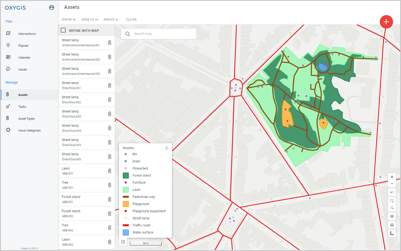
In the office or on the field, consult all your geospatial data, in map or list form. Access the description of your various assets and equipment: custom fields, photos, documents…
Personalise each of your properties with a customised description. This can take the form of free content or pre-structured data.
Also attach various media (photos, plans, instructions, etc.), accessible both on computer and on mobile.


Find all the interventions and reports made on your spaces and equipment. Keep a strong traceability of your operations. And take preventive action, thanks to this data.
Attach automatic recognition elements to your assets. This will allow you to identify them with certainty, via a simple scan on the ground.
Use official data to integrate your items reliably, without having to draw them in our asset management software.
The price of Oxygis licences is adapted according to the category of user.
For public organisations (cities, regions, inter-municipal organisations, etc.), the cost associated with using Oxygis is linked to the number of inhabitants.
For private organisations, it is the number of users that determines the price of the software dedicated to the inventory management and maintenance of your assets.
Oxygis offers dedicated support services in the form of success packs. Our entire team will dedicate a certain number of hours of work to you, to meet your needs, whether it be training, configuration or IT development.
Oxygis integrates into an existing data environment. Whether it is a matter of integrating a set of information at start-up or carrying out regular synchronization with a GIS, Oxygis puts in place the mechanisms adapted to your context and requirements.
Quickly deal with issues observed in real time on the field. Efficient asset management that reduces risks and costs.
Plan, supervise and record your corrective or preventive maintenance, depending on the availability and location of your teams.
Centralise all interventions to be carried out on the field. Assign them to the appropriate team and communicate all relevant information to them.
Take advantage of all our benefits ! In addition to our four main functionalities, our software also has a number of cross-cutting options.
Let’s meet and discuss your asset management and maintenance needs or contact us directly by email